Importer un fichier GPX

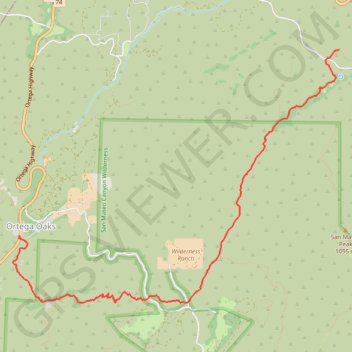
Morgan Trail and Morrell Canyon

Hike from Ortega Oaks via the Bear Canyon, the Morgan Trail and the Morrell Canyon in the San Mateo Canyon Wilderness and the Cleveland National Forest. #Hike #Nature #Canyon #Mountain #Forest #Wilderness

  • Distance : 8,4 Km
  • Dénivelé positif : 349 m
  • Altitude maximum : 888 m
  • Dénivelé négatif : 64 m
  • Altitude minimum : 602 m

Carte interactive

Profil de la trace GPS

À propos de cette trace GPS

Autres traces GPS

Cliquez sur une trace GPS pour visualiser son itinéraire, ses statistiques et son profil.

Chiquito Falls (Lyon Canyon Falls)

United States > California > Riverside County

Hike to Chiquito Falls (or Lyon Canyon Falls) via San Juan Trail and Chiquito Trail in the Cleveland National Forest. #Hike #Falls #Nature #Mountain #Forest #River

Distance : 7,0 Km • Dénivelé positif : 342 m • Altitude maximum : 808 m

Sitton Peak

United States > California > Riverside County

Hike from Ortega Oaks to Sitton Peak via Bear Canyon Trail and Sitton Peak Trail in the Cleveland National Forest and the San Mateo Canyon Wilderness. #Hike #Mountain #Nature #Forest #Canyon #Wilderness

Distance : 7,7 Km • Dénivelé positif : 524 m • Altitude maximum : 987 m

San Mateo Peak

United States > California > Riverside County

Hike to San Mateo Peak via Morgan Trail and San Mateo Peak Trail in the San Mateo Canyon Wilderness and the Cleveland National Forest. #Hike #Mountain #Nature #Forest #Park

Distance : 3,6 Km • Dénivelé positif : 238 m • Altitude maximum : 1.077 m