Importer un fichier GPX

San Mateo Peak

Hike to San Mateo Peak via Morgan Trail and San Mateo Peak Trail in the San Mateo Canyon Wilderness and the Cleveland National Forest. #Hike #Mountain #Nature #Forest #Park

  • Distance : 3,6 Km
  • Dénivelé positif : 238 m
  • Altitude maximum : 1.077 m
  • Dénivelé négatif : 33 m
  • Altitude minimum : 851 m

Carte interactive

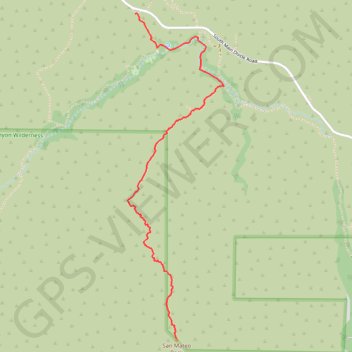
Profil de la trace GPS

À propos de cette trace GPS

Nom : Trace GPS San Mateo Peak, itinéraire, parcours

Départ : Morgan Trailhead, Riverside County, California, 92530, United States (33.63355 -117.38303)

Arrivée : San Mateo Peak Trail, Riverside County, California, 92530, United States (33.61338 -117.37998)

Coordonnées : 33.61338 -117.38356 33.63357 -117.37642

Autres traces GPS

Cliquez sur une trace GPS pour visualiser son itinéraire, ses statistiques et son profil.

Morgan Trail and Morrell Canyon

United States > California > Riverside County > Lake Elsinore

Hike from Ortega Oaks via the Bear Canyon, the Morgan Trail and the Morrell Canyon in the San Mateo Canyon Wilderness and the Cleveland National Forest. #Hike #Nature #Canyon #Mountain #Forest #Wilderness

Distance : 8,4 Km • Dénivelé positif : 349 m • Altitude maximum : 888 m