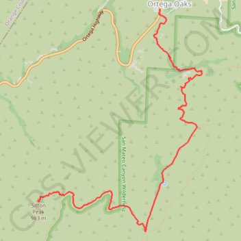
Sitton Peak
Hike from Ortega Oaks to Sitton Peak via Bear Canyon Trail and Sitton Peak Trail in the Cleveland National Forest and the San Mateo Canyon Wilderness. #Hike #Mountain #Nature #Forest #Canyon #Wilderness
- Distance : 7,7 Km
- Dénivelé positif : 524 m
- Altitude maximum : 987 m
- Dénivelé négatif : 143 m
- Altitude minimum : 600 m
Carte interactive
Profil de la trace GPS
À propos de cette trace GPS
Nom : Trace GPS Sitton Peak, itinéraire, parcours
Arrivée : Sitton Peak Access Trail, Riverside County, California, United States (33.58717 -117.44610)
Coordonnées : 33.58316 -117.44610 33.61309 -117.41977
Autres traces GPS
Cliquez sur une trace GPS pour visualiser son itinéraire, ses statistiques et son profil.