Bridge to Nowhere
Hike to Bridge to Nowhere via East Fork Trail along the East Fork San Gabriel River in the Angeles National Forest and the Sheep Mountain Wilderness. #Hike #River #Nature #Mountain #Forest #Angeles
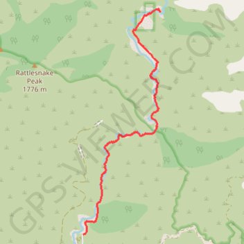
- Distance : 7,8 Km
- Dénivelé positif : 421 m
- Altitude maximum : 864 m
- Dénivelé négatif : 183 m
- Altitude minimum : 611 m
Carte interactive
Profil de la trace GPS
À propos de cette trace GPS
Nom : Trace GPS Bridge to Nowhere, itinéraire, parcours
Départ : East Fork Road, Los Angeles County, California, United States (34.23713 -117.76481)
Arrivée : East Fork Trail, Los Angeles County, California, United States (34.28278 -117.74583)
Coordonnées : 34.23713 -117.76481 34.28339 -117.74583
Autres traces GPS
Cliquez sur une trace GPS pour visualiser son itinéraire, ses statistiques et son profil.
Return from Bridge to Nowhere
United States > California > Los Angeles County
Distance : 7,8 Km • Dénivelé positif : 222 m • Altitude maximum : 875 m
Bridge to Nowhere
United States > California > Los Angeles County
Distance : 15,4 Km • Dénivelé positif : 563 m • Altitude maximum : 864 m