Apache Peak
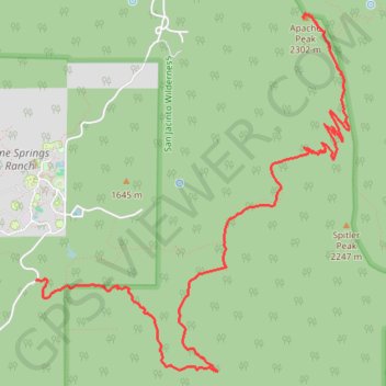
Hike from Apple Canyon to Apache Peak by the Spitler Peak Trail and the Pacific Crest Trail (PCT) in the San Jacinto Wilderness. #Hike #Mountain #Nature #Forest #PCT #Canyon #Wilderness
- Distance : 8,9 Km
- Dénivelé positif : 877 m
- Altitude maximum : 2.296 m
- Dénivelé négatif : 87 m
- Altitude minimum : 1.502 m
Carte interactive
Profil de la trace GPS
À propos de cette trace GPS
Nom : Trace GPS Apache Peak, itinéraire, parcours
Arrivée : Pacific Crest Trail, Riverside County, California, 92599, United States (33.71861 -116.62690)
Coordonnées : 33.69065 -116.65229 33.71891 -116.62252
Autres traces GPS
Cliquez sur une trace GPS pour visualiser son itinéraire, ses statistiques et son profil.
Pacific Crest Trail (PCT) through San Bernardino Forest and Santa Rosa and San Jacinto Mountains
United States > California > Riverside County
Hike from Bull Canyon Parking to Snow Creek along the Pacific Crest National Scenic Trail via Lion Peak, Pyramid Peak, Cedar Spring, Palm View Peak, Fobes Saddle, Spitler Peak, Apache Peak, Apache Spring, Antsell Rock, South Peak, Red Tahquitz, Tahquitz Meadow, Powderbox Spring, Middle Spring, Jolley Spring, Idylwild, Deer Springs…
Distance : 95,0 Km • Dénivelé positif : 3.982 m • Altitude maximum : 2.737 m