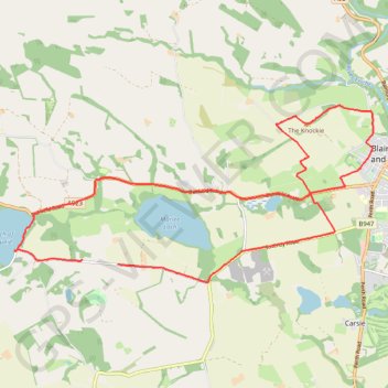
The Knockie, Marlee Loch and Loch of Clunie Loop
Loop MTB / run / hike around Blairgowrie via The Knockie, Marlee Loch and Loch of Clunie. #Hike #Loop #Nature #Countryside #Lake
- Distance : 17,2 Km
- Dénivelé positif : 271 m
- Altitude maximum : 203 m
- Dénivelé négatif : 282 m
- Altitude minimum : 49 m
- Temps en mouvement : 1 h 6 m
- Vitesse en mouvement : 15,5 Km/h
- Vitesse maximum : 46,3 Km/h
- Temps total : 1 h 7 m
- Vitesse globale : 15,3 Km/h
- Date : 02/03/24
Carte interactive
Profil de la trace GPS
À propos de cette trace GPS
Nom : Trace GPS The Knockie, Marlee Loch and Loch of Clunie Loop, itinéraire, parcours
Départ : Craigie, Perth and Kinross, Scotland, PH10 6RD, United Kingdom (56.57635 -3.41277)
Coordonnées : 56.57362 -3.44044 56.59981 -3.34424
Autres traces GPS
Cliquez sur une trace GPS pour visualiser son itinéraire, ses statistiques et son profil.