Lost Coast Trail
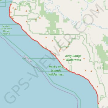
Hike from Mattole Beach to Black Sands Beach via the Lost Coast Trail, Windy Point, Punta Gorda, Cooskie Creek, Randall Creek, Spanish Flat, Kinsey Creek, Big Creek, Miller Flat, Shipman Creek, Buck Creek, Gitchel Creek and Horse Mountain Creek in the King Range Wilderness. #Hike #Coast #Sea #Pacific #Ocean #Nature #Mountain #Wilderness
- Distance : 41,8 Km
- Dénivelé positif : 718 m
- Altitude maximum : 53 m
- Dénivelé négatif : 699 m
- Altitude minimum : -1 m
Carte interactive
Profil de la trace GPS
À propos de cette trace GPS
Nom : Trace GPS Lost Coast Trail, itinéraire, parcours
Départ : Lost Coast Trail, Humboldt County, California, United States (40.28893 -124.35630)
Arrivée : Beach Road, Humboldt County, California, 95589, United States (40.04545 -124.07757)
Coordonnées : 40.04494 -124.36338 40.28942 -124.07697
Autres traces GPS
Cliquez sur une trace GPS pour visualiser son itinéraire, ses statistiques et son profil.