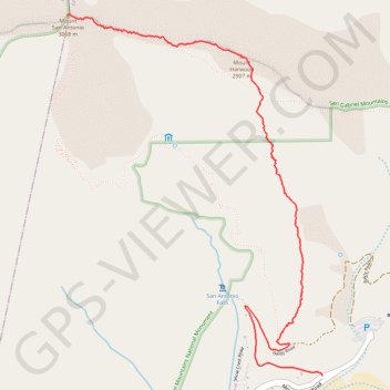
Mount San Antonio and Mount Harwood
Hike to Mount San Antonio and Mount Harwood by the Register Ridge and the Devils Backbone Trail in the San Gabriel Mountains National Monument and the Angeles National Forest. #Hike #Mountain #Nature #Forest #Angeles
- Distance : 5,7 Km
- Dénivelé positif : 1.254 m
- Altitude maximum : 3.068 m
- Dénivelé négatif : 75 m
- Altitude minimum : 1.888 m
Carte interactive
Profil de la trace GPS
À propos de cette trace GPS
Nom : Trace GPS Mount San Antonio and Mount Harwood, itinéraire, parcours
Départ : 3, Falls Road, San Bernardino County, California, 91759, United States (34.26624 -117.62688)
Arrivée : Devils Backbone Trail, Los Angeles County, California, 91759, United States (34.28912 -117.64640)
Coordonnées : 34.26624 -117.64640 34.28912 -117.62688
Autres traces GPS
Cliquez sur une trace GPS pour visualiser son itinéraire, ses statistiques et son profil.
Three T's Trail
United States > California > San Bernardino County
Loop hike to Timber Mountain, Telegraph Peak and Thunder Mountain along the Three T's Trail via Icehouse Canyon Trail, Icehouse Saddle, Mount Baldy Notch and ount Baldy Road in Angeles National Forest. #Hike #Loop #Mountain #Nature #Forest #Angeles
Distance : 24,4 Km • Dénivelé positif : 1.669 m • Altitude maximum : 2.726 m