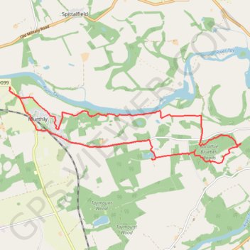
Murthly to Kinclaven Wood, Perthshire
Loop run / hike via Gellyburn, Murthly, River Tay, Ballathie Bluebell Woods and Old England Loch. #Run #Hike #Loop #Nature #Forest #River #Countryside #Lake
- Distance : 14,5 Km
- Dénivelé positif : 136 m
- Altitude maximum : 82 m
- Dénivelé négatif : 136 m
- Altitude minimum : 33 m
- Temps en mouvement : 1 h 27 m
- Vitesse en mouvement : 10,0 Km/h
- Vitesse maximum : 34,0 Km/h
- Temps total : 1 h 33 m
- Vitesse globale : 9,3 Km/h
- Date : 18/03/24
Carte interactive
Profil de la trace GPS
À propos de cette trace GPS
Nom : Trace GPS Murthly to Kinclaven Wood, Perthshire, itinéraire, parcours
Départ : B9099, Gellyburn, Murthly, Perth and Kinross, Scotland, PH1 4HN, United Kingdom (56.53701 -3.47606)
Arrivée : B9099, Gellyburn, Murthly, Perth and Kinross, Scotland, PH1 4HN, United Kingdom (56.53696 -3.47600)
Coordonnées : 56.52183 -3.47616 56.53701 -3.39273