Stanley Gap MTB Loop
Mountain Bike loop via Long Branch Loop, Toccoa River, Stanley Creek, Rocky Mountain and Green Mountain in Chattahoochee-Oconee National Forest (Blue Ridge District). #MTB #Loop #Mountain #Forest #River #Nature
- Distance : 24,9 Km
- Dénivelé positif : 941 m
- Altitude maximum : 1.016 m
- Dénivelé négatif : 945 m
- Altitude minimum : 527 m
- Temps en mouvement : 2 h 54 m
- Vitesse en mouvement : 8,5 Km/h
- Vitesse maximum : 55,3 Km/h
- Temps total : 3 h 57 m
- Vitesse globale : 6,3 Km/h
- Date : 11/09/20
Carte interactive
Profil de la trace GPS
À propos de cette trace GPS
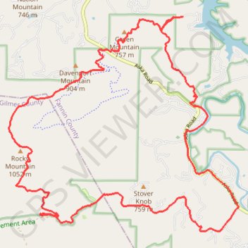
Nom : Trace GPS Stanley Gap MTB Loop, itinéraire, parcours
Départ : Fannin County, Georgia, 30513, United States (34.82380 -84.27962)
Arrivée : Fannin County, Georgia, 30513, United States (34.82392 -84.27933)
Coordonnées : 34.77781 -84.32460 34.82392 -84.26472