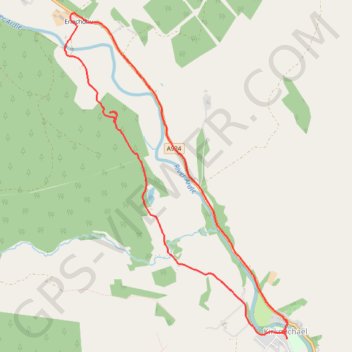
Around Kirkmichael, Perthshire
- Distance : 7,8 Km
- Dénivelé positif : 88 m
- Altitude maximum : 274 m
- Dénivelé négatif : 88 m
- Altitude minimum : 213 m
- Temps en mouvement : 56 m 55 s
- Vitesse en mouvement : 8,2 Km/h
- Vitesse maximum : 28,1 Km/h
- Temps total : 1 h 22 m
- Vitesse globale : 5,7 Km/h
- Date : 27/04/24
Carte interactive
Profil de la trace GPS
À propos de cette trace GPS
Nom : Trace GPS Around Kirkmichael, Perthshire, itinéraire, parcours
Départ : A924, Kirkmichael, Perth and Kinross, Scotland, PH10 7NT, United Kingdom (56.72301 -3.50498)
Arrivée : A924, Kirkmichael, Perth and Kinross, Scotland, PH10 7NT, United Kingdom (56.72305 -3.50502)
Coordonnées : 56.72239 -3.53595 56.74741 -3.50472
Autres traces GPS
Cliquez sur une trace GPS pour visualiser son itinéraire, ses statistiques et son profil.
Alyth to Spittal of Glenshee - Cateran Trail (some of)
United Kingdom > Scotland > Perth and Kinross > Alyth
Distance : 44,2 Km • Dénivelé positif : 1.134 m • Altitude maximum : 650 m