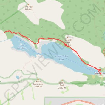
Upper Echo Lake and Lower Echo Lake
Hike from Echo Lake to Upper Echo Lake and Lower Echo Lake via Echo Pass Viewpoint and Pacific Crest National Scenic Trail (PCT) in the Lake Tahoe Basin Management Unit. #Hike #Lake #Mountain #Nature #Forest #PCT #Overlook
- Distance : 9,6 Km
- Dénivelé positif : 273 m
- Altitude maximum : 2.327 m
- Dénivelé négatif : 270 m
- Altitude minimum : 2.264 m
- Temps en mouvement : 4 h 10 m
- Vitesse en mouvement : 2,3 Km/h
- Vitesse maximum : 4,2 Km/h
- Temps total : 5 h 51 m
- Vitesse globale : 1,6 Km/h
- Date : 13/08/19
Carte interactive
Profil de la trace GPS
À propos de cette trace GPS
Nom : Trace GPS Upper Echo Lake and Lower Echo Lake, itinéraire, parcours
Départ : Echo Lakes Road, Echo Lake, El Dorado County, California, 95721, United States (38.83457 -120.04408)
Arrivée : Echo Lakes Road, Echo Lake, El Dorado County, California, 95721, United States (38.83445 -120.04378)
Coordonnées : 38.83430 -120.08339 38.84805 -120.04375
Autres traces GPS
Cliquez sur une trace GPS pour visualiser son itinéraire, ses statistiques et son profil.
Chester - Walker
États-Unis d'Amérique > Californie > Plumas County > Chester
Vélo. En aller simple entre Chester et Walker. #Vélo
Distance : 383,8 Km • Dénivelé positif : 6.088 m • Altitude maximum : 2.541 m