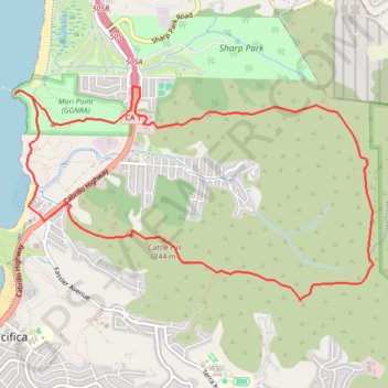
Vallemar Loop
Loop hike around Vallemar via Mori Ridge Trail, Sweeney Ridge Trail, Baquiano Trail, Castle Hill, Farallones View Trail, Rockaway Beach, Bluff Trail, Headlands Trail, The Point and Timigtac Trail in the San Francisco Peninsula Watershed, the Mori Point and the Golden Gate National Recreation Area (GGNRA). #Hike #Loop #Nature #Mountain #Sea #Pacific #Ocean #Coast #Overlook #Beach #GGNRA
- Distance : 12,1 Km
- Dénivelé positif : 560 m
- Altitude maximum : 375 m
- Dénivelé négatif : 562 m
- Altitude minimum : 0 m
- Temps en mouvement : 2 h 28 m
- Vitesse en mouvement : 4,9 Km/h
- Vitesse maximum : 6,5 Km/h
- Temps total : 2 h 29 m
- Vitesse globale : 4,8 Km/h
- Date : 04/06/23
Carte interactive
Profil de la trace GPS
À propos de cette trace GPS
Nom : Trace GPS Vallemar Loop, itinéraire, parcours
Coordonnées : 37.60126 -122.49871 37.62062 -122.45782